
A powerful offshore 7.8-magnitude earthquake struck the southern Philippines early Monday, resulting in at least four deaths and leaving over 200 people injured. The seismic event triggered a 3-foot tsunami that washed ashore on nearby coastal areas, prompting urgent evacuations.
The quake struck around 7:37 a.m. and was centered at sea approximately 8 miles southwest of General Santos, a major commercial and tuna-processing hub in the Mindanao region with a population exceeding 700,000. According to the Philippine Institute of Volcanology and Seismology, the quake was caused by movement in the Cotabato Trench at a depth of 6.2 miles. The U.S. Geological Survey measured the depth at 34 miles and reported strong aftershocks reaching up to a 6.5 magnitude.
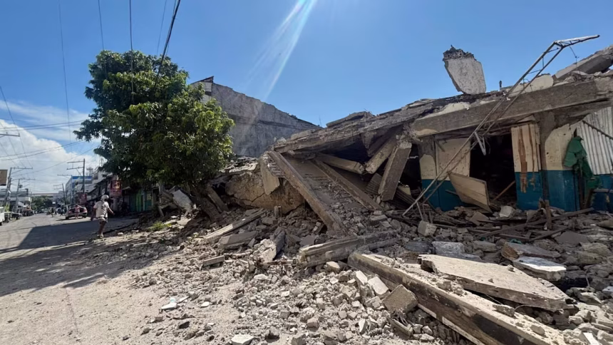
In General Santos, at least three people were killed and 130 injured as some small buildings partially collapsed and a crucial access bridge sustained severe cracks. An additional fatality was reported by the Department of Health in Davao Oriental province.
The earthquake struck right as the work and school week was beginning. Ednar Dayanghirang, a regional director of the Office of Civil Defense, noted that more than 100 students sustained bruises or fainted in a panic during morning flag-raising ceremonies at local schools. The severe shaking also led to the temporary closure of the international airport in General Santos, resulting in the cancellation of 17 domestic flights. Debris from a partly collapsed commercial building in Manila hit parked tricycle taxis, though workers inside managed to evacuate without injuries.
Following the massive tremor, land-based tsunami watch stations measured 3-foot waves in the provinces of Sultan Kudarat and Sarangani. A 2.7-foot wave was also detected off the coast of Indonesia’s Sulawesi island. Philippine President Ferdinand Marcos Jr. swiftly urged residents in vulnerable areas to evacuate, stating, “Move to higher ground now. Do not wait. Your life is more important than anything left behind”.
Tsunami warnings were also issued by Indonesian authorities, as well as by Malaysia’s Meteorological Department for Sabah state on Borneo island. The Pacific Tsunami Warning Center stated that while the major tsunami threat had largely passed roughly five hours after the initial tremor, coastal residents were urged to remain alert as sea levels could continue to fluctuate.
The Philippines is located along the seismically active Pacific “Ring of Fire,” making it highly vulnerable to devastating earthquakes and volcanic activity. President Marcos assured the public that disaster-response teams are actively mobilized, stating, “The national government is moving, and we will not leave Mindanao behind”.