
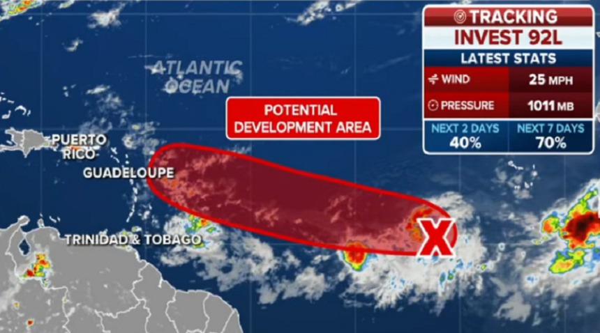
The Atlantic hurricane season is “springing back to life” this week as the National Hurricane Center (NHC) has officially designated Invest 92L in the Atlantic’s Main Development Region (MDR). After a period of relative quiet, tropical activity is heating up, with forecasters keeping a close eye on two distinct disturbances moving off the African coast.
As of the latest reports, Invest 92L is producing maximum sustained winds of 25 mph with a central pressure of 1011 millibars. The NHC currently gives the system a 40% chance of development within the next 48 hours, but those odds jump to a significant 70% chance over the next seven days.
While Invest 92L still has a way to go to become fully organized, visible satellite imagery already shows signs of organized convection.
Forecasters note that Invest 92L has found a rare pocket of calm in an otherwise hostile environment. It is currently positioned south of the strong upper-level winds that typically tear developing systems apart. Additionally, it is sitting south of the major Saharan dust plumes that often dampen tropical activity this time of year, allowing it to wrap available moisture into its center to gain strength.
Invest 92L may not be the only threat on the horizon. A second tropical wave is already emerging from the African coast directly behind it. Experts suggest that Invest 92L could “pave the way” for this trailing system, acting like a “slip and slide” by wrapping moisture into the region and creating a more favorable roadmap for the second disturbance to develop.
Interestingly, there is a split between weather models regarding which system will be more dominant:
- Traditional Models: The GFS and Euro models currently favor the leading disturbance, Invest 92L.
- AI Models: The Google AI and other AI models are trending toward the trailing second disturbance as the one with higher development potential.
While it is still early and the storm’s path remains sporadic, current trends suggest a northward turn that could eventually bring the system near Bermuda.