


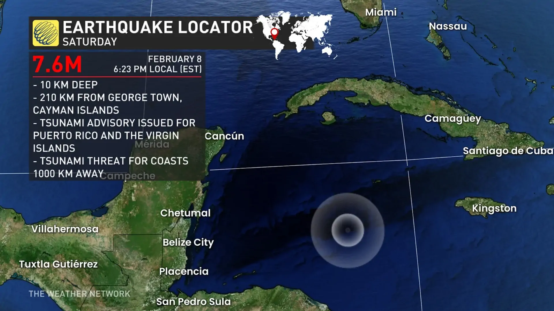
A very strong earthquake registered by the USGS as M7.6 hit the Cayman Islands region at 23:23 UTC on February 8, 2025. The agency is reporting a depth of 10 km (6.2 miles). EMSC is reporting the same magnitude and depth.

Image credit: TW/SAM, Google
The epicenter was located 210 km (130 miles) SSW of George Town (population 29 370), Cayman Islands.
67 000 people are estimated to have felt light shaking.
Based on the preliminary earthquake parameters (M7.6), hazardous tsunami waves are possible for coasts located within 1 000 km (620 miles) of the earthquake epicenter, NWS PTWC said.
This includes the coasts of the Cayman Islands, Jamaica, Cuba, Mexico, Honduras, the Bahamas, San Andrés Providencia, Belize, Haiti, Costa Rica, Panama, Nicaragua, and Guatemala.
Estimated times of arrival:
| Location | Region | Coordinates | ETA (UTC) |
|---|---|---|---|
| Cayman Brac | Cayman Islands | 19.7N 79.9W | 23:52 02/08 |
| Grand Cayman | Cayman Islands | 19.3N 81.3W | 23:58 02/08 |
| Montego Bay | Jamaica | 18.5N 77.9W | 00:03 02/09 |
| Cienfuegos | Cuba | 22.0N 80.5W | 00:11 02/09 |
| Santiago D Cuba | Cuba | 19.9N 75.8W | 00:18 02/09 |
| Cozumel | Mexico | 20.5N 87.0W | 00:19 02/09 |
| Puerto Cortes | Honduras | 15.9N 88.0W | 00:21 02/09 |
| Trujillo | Honduras | 15.9N 86.0W | 00:40 02/09 |
| Kingston | Jamaica | 17.9N 76.9W | 00:42 02/09 |
| Baracoa | Cuba | 20.4N 74.5W | 00:48 02/09 |
| Great Inagua | Bahamas | 20.9N 73.7W | 00:49 02/09 |
| La Habana | Cuba | 23.2N 82.4W | 00:58 02/09 |
| San Andres | San Andres Provi | 13.4N 81.4W | 01:07 02/09 |
| Belize City | Belize | 17.5N 88.2W | 01:08 02/09 |
| Providencia | San Andres Provi | 12.6N 81.7W | 01:14 02/09 |
| Long Island | Bahamas | 23.3N 75.1W | 01:21 02/09 |
| Jeremie | Haiti | 18.6N 74.1W | 01:26 02/09 |
| Exuma | Bahamas | 23.6N 75.9W | 01:37 02/09 |
| Puerto Limon | Costa Rica | 10.0N 83.0W | 01:53 02/09 |
| Gibara | Cuba | 21.1N 76.1W | 01:55 02/09 |
| Andros Island | Bahamas | 25.0N 77.9W | 02:03 02/09 |
| Bimini | Bahamas | 25.8N 79.3W | 02:17 02/09 |
| Nassau | Bahamas | 25.1N 77.4W | 02:20 02/09 |
| Colon | Panama | 9.4N 79.9W | 02:25 02/09 |
| Bocas Del Toro | Panama | 9.4N 82.2W | 02:30 02/09 |
| Punta Gorda | Nicaragua | 11.4N 83.8W | 02:36 02/09 |
| Santa Cruz D Sur | Cuba | 20.7N 78.0W | 02:43 02/09 |
| Nueva Gerona | Cuba | 21.9N 82.8W | 03:13 02/09 |
| Puerto Barrios | Guatemala | 15.7N 88.6W | 03:27 02/09 |
| Progreso | Mexico | 21.3N 89.7W | 04:22 02/09 |
| Puerto Cabezas | Nicaragua | 14.0N 83.4W | 05:51 02/09 |
| Campeche | Mexico | 19.9N 90.5W | 06:05 02/09 |
The PTWC advised government agencies responsible for threatened coastal areas to take immediate action to inform and instruct populations at risk. These actions should be based on their own evaluation of the situation, established procedures, and the assessed level of threat. Authorities should ensure timely communication and provide clear directives to mitigate potential impacts.
Individuals in threatened coastal areas should remain alert for updates and follow instructions issued by national and local authorities. It is essential to stay informed through official channels and take precautionary measures as advised. Evacuation orders, if given, should be followed promptly to ensure personal safety.
The USGS issued a Green alert for shaking-related fatalities and economic losses. There is a low likelihood of casualties and damage.
Overall, the population in this region resides in structures that are vulnerable to earthquake shaking, though resistant structures exist. The predominant vulnerable building types are mud wall and informal (metal, timber, GI etc.) construction.
