
Category: Weather Update

  • SVG braces for approaching tropical wave

    SVG braces for approaching tropical wave

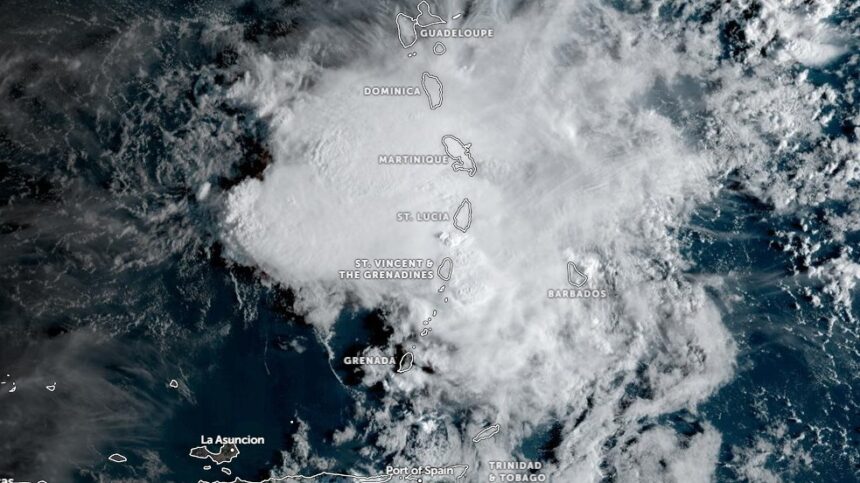
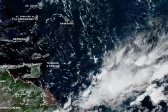
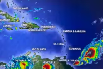
    The St. Vincent and the Grenadines Meteorological Services issued a comprehensive 72-hour weather outlook today, warning residents of a combination of reduced air quality due to Saharan dust and inclement weather from an approaching tropical wave.

    Saharan Dust Impacts Visibility and Health Currently, varying concentrations of Saharan dust haze are crossing the islands, leading to a significant reduction in visibility and air quality. While the haze is expected to thin out starting early Saturday, forecasters warn that a thick plume is projected to return by Monday. Residents, particularly those with respiratory sensitivities, are strongly advised to take all necessary precautions during this period.

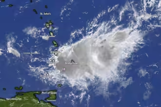
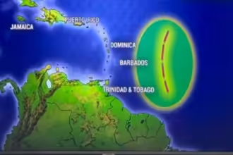
    Tropical Wave to Bring Heavy Rains and Thunderstorms The Meteorological Service is also tracking a tropical wave expected to begin affecting the islands as Saturday progresses. Weather conditions are predicted to deteriorate by late Saturday evening with an increase in shower intensity.

    The forecast for the next three days includes:

    • Saturday, July 11th: Partly cloudy to cloudy conditions, remaining hazy and breezy with showers and isolated thunderstorms. A weather advisory is in place for residents to remain alert.
    • Sunday, July 12th: Conditions will worsen to cloudy or overcast. Forecasters are warning of showers, thunderstorms, and potential excessive rainfall, urging the public to exercise extreme caution.
    • Monday, July 13th: Some slight improvement is expected, with weather becoming fair to occasionally cloudy, though hazy conditions will persist with a few lingering showers.

    Hazardous Marine Conditions and High Winds Strong north-easterly trade winds, averaging 40 km/h with higher gusts, are currently impacting the region. Winds are expected to shift to an easterly direction on Saturday and Monday.

  • Showers persist, caution advised for mariners in SVG

    Weak unstable conditons linger across our islands, with cloudy skies and a few scattered showers across St. Vincent and the Grenadines (SVG)…Residents and motorists in areas prone to flash-flooding and landslides or near rivers and streams should be/remain alert. By late Wednesday, cloudiness is likely to decrease and the film of haze across our area is expected to thin-out.

    Moderate-fresh (20 – 35km/h) breeze continues across our islands tonight and Wednesday morning, becoming gentle-moderate (15 – 25km/h) during Thursday and Friday. Wind directions could vary from east northeast to east southeast in some locations.

    Sea conditions are slight to moderate in open water, with swells ranging 1.0m (3ft) to 1.5m (5ft) west of our islands and ranging 1.5m (5ft) to 2.5m (8ft) east of our islands with

    occasional northerly swellsSmall-craft operators and sea-bathers should exercise caution for above normal swells and occassional gusty winds, during Wednesday.

  • Dangerous rip currents to affect SVG starting Christmas day

    The St. Vincent and the Grenadines Meteorological Services issued a formal marine advisory to warn the public about hazardous coastal conditions beginning on Christmas Day 2025.

    The advisory explains that Low Pressure areas in the North Atlantic are generating strong sea swells and dangerous rip currents that will impact the islands’ shores.

    Specifically, the advisory alerts small-craft operators and swimmers to remain vigilant, as long-period waves and breaking surf are expected to make the water unsafe.

    To assist with safety planning, the advisory lists daily high-tide schedules for the duration of the alert, as rising water levels may worsen the situation.

    Officials intend for these safety precautions to remain in effect through Monday evening, though the timeline may shift based on evolving weather patterns.

    Upcoming High-tide times:
    Thursday 25th 08:31am and 11:33pm
    Friday 26th 09:18am and 11:47pm
    Saturday 27th 10:12am
    Sunday 28th 00:14am and 11:13pm
    Monday 29th 00:49am and 12:22pm

  • Small-craft, high surf advisory in effect for SVG

    A Small-craft and High Surf Advisory is in effect for St Vincent and the Grenadines and its coastal waters from today 12:00 Noon Saturday 6th December 2025 until 12:00 Noon Tuesday 9th December, 2025. 

    A Small-Craft Advisory is issued when sustained winds of 37 to 46 km/h (23 to 29 mph) and/or sea swells of 2.5 to 3.0 meters (8 to 10 feet) are affecting or forecast to affect the marine area within the next 36 hours. 

    A High Surf Advisory is issued when breaking wave action is forecast to pose a threat to life and property within the surf zone during the next 36 hours. 

    Large waves and dangerous rip-currents will create unsafe conditions for small-craft operators, particularly on the northern and eastern coastlines. 

     These conditions may become even more adverse at times of high tide. 

     Therefore, only vessels capable of withstanding swells of these magnitudes should venture out. Sea-bathers are advised to stay out of the water. 

    Upcoming High-tide times: 

    Saturday (today) 09:52 pm 

    Sunday 07:01 am and 10:14 pm 

    Monday 10:30 am and 11:53 pm 

    Tuesday 08:05 am 

    This advisory may be discontinued at 12:00 Tuesday 9th December 2025 or sooner if conditions improve. It may also be extended if conditions warrant. 

  • Saharan dust to reduced air quality, visibility across SVG

    SVG can expect breezy conditions to persist this week. Saharan dust haze continues will continue to cross our islands during this forecast period. Residents should remain alert for reduced air quality and visibility.

    A ridge pattern would dominate the conditions within the next 48 hours allowing for a few sporadic showers. Around late Wednesday unstable conditions will instigate unsettled conditions across SVG.

    This would continue on Thursday. Residents should remain alert.

    Fresh to strong (~30-45 km/h) east north easterly trades will cross our islands within the next 36 hours. Consequently, seas will become further agitated.

    A small craft and high surf advisory is in effect for SVG and its coastal waters. Seas are moderate in open water with swells increasing to beyond 2.5m in the next few days.

    Only vessels capable of withstanding swells of these magnitudes should venture out. Sea-bathers are advised to stay out of the water.

  • Weather to deteriorate across SVG in 24 hours

    A FLASH-FLOOD WATCH IS IN EFFECT FOR ST. VINCENT & THE GRENADINES

    Unstable conditions will begin to cross our islands under a favorable mid to upper level environment and this will result in deteriorating conditions across St. Vincent & the Grenadines within the next 24 hours.

    Showers are expected to increase in intensity Thursday night into Friday as moisture levels increase across our islands.

    Periods of light rain and isolated thunderstorms are also anticipated across St Vincent and the Grenadines within the next 24 hours.

    In addition, rainfall accumulations of 50-100mm (approximately 2-4 inches) with isolated higher amounts in mountainous areas are also possible.

    As a result, a flash flood watch is now in effect for SVG from 6pm today, Thursday 5th June 2025 until Friday 6th June 2025.

    Residents and motorists in areas prone to flooding and landslides or near rivers and streams should be prepared.

    A Flood-Watch is issued when conditions are favorable and there exists the possibility of flooding during the watch period.

    This flash-flood watch may be upgraded to a warning if conditions warrant.

  • 2025 Atlantic hurricane season kicks off: what you need to know

    Officially starting today, June 1, 2025, the 2025 Atlantic hurricane season runs until November 30, 2025.

    Historically, tropical storms and hurricanes capable of causing great damage define the Atlantic hurricane season. Forecasts and analysis offered by the National Oceanic and Atmospheric Administration (NOAA) enable local governments to get ready for the hazards these storms bring. NOAA has projected an above-average degree of activity for the 2025 season, with between 13 and 19 named storms estimated and 6 to 10 possibly becoming hurricanes and 3 to 5 reaching major hurricane status.

    The official dates for the hurricane season, from June 1 to November 30, are based on climatological data that indicates the highest frequency of tropical cyclone activity during these months. However, it is crucial to note that storms can and do form outside this timeframe, although such occurrences are relatively rare.

    Forecasting models suggest a 60% chance of an above-average hurricane season, which emphasizes the need for preparedness among residents in vulnerable areas. Local governments and emergency management agencies are encouraged to initiate awareness campaigns and ensure that residents are equipped with evacuation plans, emergency kits, and up-to-date information on shelters

    The implications of an active hurricane season extend beyond immediate physical dangers. Economically, hurricanes can disrupt supply chains, damage infrastructure, and lead to significant financial losses for communities and businesses alike. From an environmental perspective, hurricanes can alter ecosystems, cause erosion, and impact wildlife habitats.

    List of 2025 hurricane names

    • Andrea
    • Barry
    • Chantal
    • Dexter
    • Erin
    • Fernand
    • Gabrielle
    • Humberto
    • Imelda
    • Jerry
    • Karen
    • Lorenzo
    • Melissa
    • Nestor
    • Olga
    • Pablo
    • Rebekah
    • Sebastien
    • Tanya
    • Van
    • Wendy

    The list is one of six that are rotated every year, meaning this list was last used in 2019 and will be used again in 2031. The names are set by the World Meteorological Organization, a United Nations agency.

    A name is retired and replaced if it is used for a storm that is extremely deadly or costly, making it inappropriate to reuse for future storms.

    Personal hurricane kit

    Build a bag with everything you’ll need in a backpack or two in case you have to evacuate.

    • Air horns or whistles, to call for help
    • Assorted batteries, including for hearing aids
    • Backpacks, sturdy and waterproof
    • Can opener (manual, never electric)
    • Cash (no power or cell service means no credit cards or mobile payments)
    • Disinfecting wipes
    • Extra clothing and socks, including something warm in case it gets cold
    • First-aid kit
    • Hand sanitizer
    • Handheld lanterns
    • Headlamp and batteries
    • Identification, insurance cards, etc.
    • Insect repellent
    • NOAA Weather Radio, battery or hand-crank
    • Nonprescription medication (anti-diarrheal, pain relievers, etc.)
    • Pens and paper (don’t run down your phone battery by writing stuff down)
    • Personal wipes (antibacterial)
    • Phone charging cables, wall chargers
    • Portable power banks for smartphones and tablets
    • Rain jacket and pants/poncho
    • Rubber boots
    • Safety work gloves
    • Spare contacts and eyeglasses (also eyedrops)
    • Spare keys to homes, businesses and vehicles
    • Sturdy boots or shoes (and a backup pair)
    • Sunscreen, lip balm
    • Sleeping bags
    • Toothbrushes, toothpaste, floss
    • Water purification tablets
    • Waterproof folders, for documents and photos
    • Waterproof matches, lighter

    Home hurricane kit

    If you lose power after a storm, if your home or neighborhood gets hit hard or if help is unable to reach you for a while, this gear will make your wait at home more tolerable.

    • Bleach (to clean up mold)
    • Carbon monoxide detector, battery-powered (for gas-powered generators)
    • Can opener (manual, never electric)
    • Disinfecting wipes
    • Duct tape
    • Extra water (fill bathtubs for flushing)
    • Hand soap
    • Fan, battery-operated
    • Fire extinguisher
    • First-aid kit
    • Garbage bags, plastic sheeting (for garbage and covering broken windows)
    • Insect repellent
    • Long-handle squeegees for scraping mud out of a flooded home
    • Laser pointer, to attract help in the dark (Aiming one at an aircraft is a crime.)
    • Laundry detergent, bucket for washing clothes
    • NOAA Weather Radio, battery or hand-crank
    • Paper cups, plates, plastic utensils
    • Paper towels (better than sponges if there’s no water)
    • Personal wipes (antibacterial)
    • Portable air conditioner that can run off a generator
    • Portable camping stove
    • Portable generator (Never operate one indoors or near a door or window; beware of carbon monoxide poisoning.)
    • Portable power banks for smartphones and tablets
    • Powerful flashlight
    • Rags, sponges and mops for cleanup
    • Safety work gloves
    • Spray paint (to paint address, insurance carrier on house)
    • Surge protectors or power strips
    • Tarps (for damaged roofs, walls and windows)
    • Termite bait and ant poison
    • Toilet paper
    • Tool kit
    • Toothbrushing pads (when water is in short supply)
    • Wrench or pliers, to turn utilities on and off

    Vehicle hurricane kit

    In an emergency, your vehicle may be the safest place you can stay after a storm.

    • Car shovel/pick
    • Cash (tow trucks and repair shops may not take electronic payment)
    • Disinfecting wipes
    • Duct tape
    • Emergency blankets
    • Fire extinguisher
    • First-aid kit
    • Fuse kit
    • Garbage bags, plastic sheeting (for garbage and covering broken windows)
    • Jumper cables
    • Maps, map books, gazetteer (physical, not digital; must be up to date)
    • Multitool
    • Personal wipes (antibacterial)
    • Phone cables
    • Pocketknife
    • Portable air compressor
    • Portable jump starter
    • Power inverter, for charging devices
    • Safety work gloves
    • Spare tire (that actually works)
    • Tire jack
    • Tire sealant, puncture repair kit
    • Vehicle registration, proof of insurance
    • Water repellant

    Children’s hurricane kit

    Children need a hurricane kit, too. If you’re breastfeeding, experts say to keep a week’s worth of powdered formula on hand, just in case.

    • Baby food
    • Baby wipes
    • Blankets, pillows
    • Books, games, playing cards, puzzles (Do not rely on electronic devices to entertain children.)
    • Child’s insurance ID
    • Clean bottles
    • Diapers
    • Drawing paper, crayons, markers, pens
    • Dry, extra clothing and underwear
    • Formula
    • Kid-friendly canned goods
    • Medical alert bracelet (if needed)
    • Nonprescription medication (anti-diarrheal, pain relievers, etc.)
    • Personal wipes (antibacterial)
    • Sturdy shoes, rubber boots
    • Toothbrushes, toothpaste, floss
    • Toys (that can be damaged or lost)

    Pet hurricane kit

    Getting your pet microchipped will help ensure you’ll be reunited with Fido or Kitty if you’re separated. Keep your microchip contact information up to date. Make sure your pet is also wearing a tag with your current contact information. Some shelters accept pets, but you’ll still need to pack their gear. The CDC has a pet emergency kit checklist at cdc.gov/healthy-pets/media/pdfs/disaster-prep-Pet-Emergency-Checklist-1.pdf.

    • Blanket
    • Cat litter, newspaper, even paper towels
    • Crate or sturdy carrier
    • Disposable litter trays for cats
    • Disposable bags for pet cleanup
    • Extra collar with updated pet tag, contact information
    • Extra leashes
    • Medications (30-day supply)
    • Medical records
    • Muzzle
    • Pet first-aid kit
    • Pet food (seven-day supply)
    • Pet microchip (keep updated)
    • Pet toys
    • Pet wipes
    • Portable food and water bowls
    • Puppy pads
    • Recent photos of pets (in case you’re separated)
    • Service animal supplies
    • Treats

    First-aid kit

    You can buy a first-aid kit or build one yourself.

    • Allergy medication
    • Aloe
    • Antacid
    • Anti-diarrheal medication
    • Antihistamine cream
    • Antiseptic agent
    • Antiseptic wipes
    • Aspirin, pain-relievers
    • Burn relief spray
    • Cotton balls/swabs
    • Eyewash
    • First-aid manual
    • Hand sanitizer
    • Hypoallergenic adhesive tape
    • Instant cold compress
    • Latex gloves
    • Laxative
    • Moistened towelettes
    • Mosquito repellent
    • Petroleum jelly
    • Safety pins
    • Sewing needle
    • Scissors
    • Soap
    • Splint
    • Sterile adhesive bandages (all sizes)
    • Sterile gauze pads
    • Sunscreen
    • Triangular bandages
    • Thermometer
    • Tweezers
  • Thunderstorms, Heavy Showers Expected Across SVG This Evening

    Unstable conditions are crossing the islands and cloudy skies, periods of rain, moderate-heavy showers and thunderstorms expected across St. Vincent and the Grenadines (SVG) this evening.

    Trough systems are expected to maintain high moisture levels across SVG for a few days, maintaining occasional showers and thunderstorm activity…Residents and motorists in areas prone to flash-flooding and landslides or near rivers and streams should remain alert and exercise caution. Slightly cooler air may also be noticeable especially during night-times.

    Light-gentle (< 20km/h) breeze across our islands could increase (20 – 25km/h) near showers and wind directions vary between north-east and east south-east in some locations.

    Sea conditions are slight to moderate in open water, with northerly swells near 1.0m west of our islands and 1.5m east of our islands…Small-craft operators and sea-bathers should continue to exercise caution for rip currents. Swell heights fall (0.5 – 1.2m) across SVG by Monday night.

  • Approaching Trough to Bring Showers, Thunderstorms to SVG

    Another low-level trough is approaching the islands and occasional cloud patches could trigger a few showers across St. Vincent and the Grenadines(SVG). Cloudiness, scattered showers and thunderstorms are likely across SVG by Friday. Good visibility continues across our islands.

    Light-gentle (< 20km/h) north-easterly trades are crossing our islands, occasionally increasing to a moderate (~ 25km/h) breeze. Wind directions are expected to turn south-easterly by Friday.

    Sea conditions are slight in open water, with swells near 0.5m west of our islands and up to 1.2m east of our islands. Slight-moderate (0.5m – 1.5m) sea conditions are expected across our islands by late Thursday, with northerly swells during Friday…Small-craft operators and sea-bathers should be alert for occasional rip currents.

    The Atlantic Hurricane Season officially lasts from 1 June to 30 November. Areas of concern are likely to develop across the Caribbean Sea during November and drift eastward…The St. Vincent and the Grenadines Meteorological Services will continue to monitor developments across the Caribbean Sea and Tropical Atlantic Ocean, issuing updates/advisories as necessary.

  • SVG Met Warns of Changing Weather Patterns

    A tropical wave is crossing the islands, with a few scattered showers and isolated thunderstorms across St. Vincent and the Grenadines(SVG). Meanwhile, Saharan dust concentrations continue to create slight-haze across our area, thickening to moderate-haze with poor visibility by this (Thursday) evening.

    Dust concentrations are expected to thin-out across our area by late Saturday, as a lower-level trough crosses the islands with a few showers.

    Moderate-fresh (20 – 35km/h) breeze across our islands vary between north-east and east south-east in some locations, possibly gusting near 40km/h tonight…Be Alert!

    Sea conditions are slight to moderate in open water, with swells near 1.2m west of our islands and up to 2.0m east of our islands. Swell heights are gradually rising, becoming moderate (1.5m

    • 5m)across SVG during Thursday night and Friday…Small craft operators and sea bathers should exercise caution for rising swells, gusty winds and reducing visibility…Swells gradually return to slight-moderate (1.0m – 1.5m) conditions across SVG by Sunday.

    The St. Vincent and the Grenadines Meteorological Services will continue to monitor the Tropical Atlantic Ocean and issue updates/advisories as necessary.